
The line between badass and dumbass is not only fine, it is a
grey, wavy line, and in a different place for each individual. It’s hard to
recognise, easy to miss, and painfully clear when overstepped. It’s the concept
of pushing hard and not giving up, balanced against blind ambition and getting
in too deep. Basically, when you start to get really scared, you are probably approaching
your line.
-Leo Holding
I’ve got to start another blog with a confession – I was
born and raised in Utah but it took me 30 years to finally go hiking in the
Uinta Mountains. I’ve done field work in
some of the wetlands in the range and I’ve hiked a whole lot of other places in
Utah, but I’ve never visited this range just for recreating. And that’s unacceptable. Fortunately I fixed that whole situation by
visiting for a few days during my solitary-post-field-work-internal-battery-recharging-end-of-summer
adventure. The plan was to hike King’s
Peak in a day and spend the next day fishing the head waters of the Bear,
Weber, and Provo Rivers.
 |
| Sunrise at Henry’s Fork |
The Uintas are a unique mountain range, being the longest east-west
running mountain range in the United States, and critical to Utah, being the
source of 90% of the water in the state.
The highest point in Utah, King’s Peak – elevation 13,528 ft, prominence
6,358 ft – is located in the High Uintas Wilderness. Especially interesting to me, the Uintas are
the source of the three rivers that provide most of the water to the Great Salt
Lake and associated wetlands. The Bear
River begins on the North Slope of the Uintas and flows north through Utah,
Wyoming, and Idaho before it ends in the GSL. The Weber River begins in the western end of
the range and flows along through some dang scenic Utah towns like Kamas before
following Interstates 80 and 84 into the Ogden area. Finally, the Provo River starts in the
southwestern end of the mountains, is impounded in a series of Central Utah
Project reservoirs before flowing on down to Utah Lake; the Jordan River flows
out of Utah Lake into the Great Salt Lake.
 |
| There are thousands of lakes nestled in the Uintas |
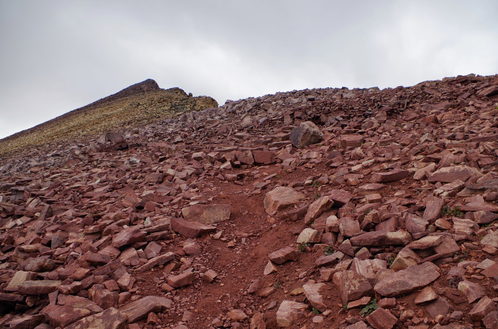
The shortest trail to King’s Peak is 32 miles long,
beginning at the Henry’s Fork Trailhead at 9,430 ft, then climbing 4,100 feet
up to the peak through the Henry’s Fork Valley to Gunsight Pass, then Anderson
Pass, finally up a boulder-y ridgeline to the peak. Most people backpack it because there are
some delightful places to set up camp in the valley and 32 miles in one day is
a bit silly. But I’m not a strong
backpacker (backpacks make my shoulders feel pinchy) and the weather report I read
suggested temps would hover between 30º
and 50º, which is
just too cold for me and my lightweight sleeping bag (its rated to 20º or so but I couldn’t imagine
sleeping comfortably), so my plan was to spend the night at lower elevation
(where it might get as warm as 60º) and do the whole out and back trail in one
day.
 |
| The double-sleeping bag oven I could put together car camping |
I figured
my hiking pace averages two miles per hour, faster in flatter areas, slower in
the steep places, so I’d need 16 hours to do the whole thing. In order to get to the peak before the
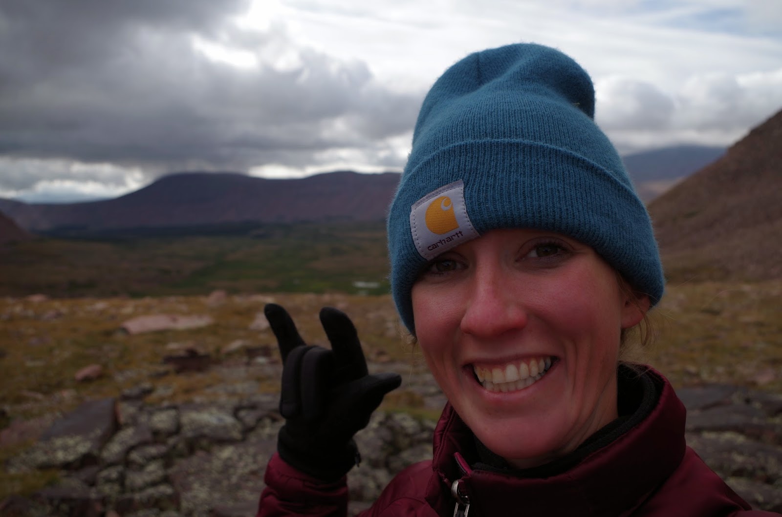
regularly scheduled afternoon thunderstorms I started at 4:00 a.m.
 |
| 4 a.m. Game face |
I
actually meant to start at 3:00 a.m., but I slept a little better than
anticipated and don’t know how to work the alarm on my watch. I went to bed pretty nervous as I listened to
the rumble of thunderstorms to the north and south, but woke feeling badass and
got a pretty strong start hiking in the dark.
I could hear the Henry’s Fork River below me and imagined it was
beautiful. The sun was rising as I
entered the valley and was greeted with a view of the socked in King’s Peak
 |
| I misunderstood which of the peaks was actually King’s, it’s on the left side of the picture and it looked like this (cloudy) for most of the hike up. |
I hiked
for four hours before I met anyone else on the trail, a group from Montana that
passed me while I stopped to finish my coffee at the top of the
valley. We chatted a bit while they
waited for their last hiker to catch up and they made me feel so cool. I told them I was hiking the whole thing in a
day and they told me how intense that was and they complimented my choice of
morning coffee spots. As they hiked away
I felt like a pretty serious badass, I’d gotten up before everyone else and I
was going to get down before them too.
 |
| No regrets here, just enjoying the coffee and view |
As I
approached Gunsight Pass, the divide between Henry’s Fork and Painter Basin
– elevation 11,888 feet – I passed my new Montana friends and gained some
spectacular views as well as my first sighting of the weather I’d be dealing
with at this higher elevation.
 |
| Yes, it did snow that night. |
I tore
out a few pages from my hiking guide book and read them before heading up
Gunsight. I remembered the author said
to follow the trail into Painter Basin, which takes away a few hundred feet of
elevation, because it wasn’t worthwhile to scramble along the talus slope, but
I got distracted by the site of some ptarmigans (yeah! a new bird) and misinterpreted “The trail does not continue
through the low notch as easily as it may appear from below, however. There are thickets and boulders here, and the
trail switches back up the west slope to the pass…” as “…follow the boulders up
to the pass.” It wasn't that hard. I’m just that hard core.
 |
| See, White-tailed ptarmigans. |
 |
| I’m loving Gunsight Pass |
 |
| How great would it be to spend the summer looking at these wetlands? Great. |
Then the trail started to gain some serious vertical ground
as it went up to Anderson Pass. When I
hit spots like this I imagine down-shifting just like a car so I can climb
slowly but efficiently. I felt alright
about it until I looked behind me to see a couple trail runners were gaining on
me. I’d felt so proud that I dressed
properly for my climb up past 13,000 feet (I’d really underestimated the weather
at high elevations when I tried to climb the Grand Teton), then I saw these
guys coming up the mountain in shorts, windbreakers and weird mittens. Then they told me they’d started three hours
after me. But they were nice enough to
chat with me about what they were doing and the speed they were going at, which
left a pretty good impression on me. One
of the things I like about running is that it is so easy to rescale the effort
based on personal levels of fitness and goals.
For me it’s enough to maintain 10-minute miles for the course of a
marathon, I don’t need the same 4,100 foot elevation gain those runners
did. Chewing on the things that are
great about running and hiking got me through the next 1.5 miles or so, until I
realized I needed to start munching on something with real calories because I
kept losing the trail. But really the
trail had just petered out into rocks and tundra plants.
 |
| Tundra plus marmot |
As I got within a mile of Anderson Pass I started running
into hikers going downhill so I asked them if they went for the peak to get an
idea of the safety. No one had, some had
no intention of it and others didn’t like the look of the storm. As I sat eating my pepperoni and string
cheese, feeling the sting of a little snow, I dug into the bravery reserves I
keep inside and decided the clouds weren’t nearly formidable enough to stop me
and committed to going up. Plus I could
see the trail runners ahead of me and they looked epic scrambling along the
ridge line.
 |
| Socked-in weather before I headed up |
The last mile to King’s Peak was a
combination of feeling pretty cool and pretty lost. I’m not a strong path finder and there’s not
actually a path up to the top. Instead,
you just kind of head over boulders up and to the south until you find a flag
at the top (but not a USGS summit marker, which is over on South King’s Peak). I tried to channel my inner mountain goat to
make a speedy ascent, continually looking around at the clouds and adding up
the amount of time I’d spend unprotected from potential lightening. A mountain goat wouldn’t be scared of
lightening. A mountain goat wouldn’t be
so gassy. A mountain goat is a badass
and my spirit animal. (Fun fact – I just googled "burping at high
altitude" and found out that "high altitude flatus expulsion (HAFE)" is a real
thing. As air pressure decreases with
altitude, the internal pressure created by intestinal gasses increases and
makes hikers burp and fart as they get out of their comfort zone. The first result of my google was a list of
terrifying symptoms of HAPE and HACE, pretty scary high altitude
diseases.)
 |
| Isn’t that a beautiful hike |
It took me an hour to mountain
goat my way to the summit. It was pretty
fun to think about how deep the giant pile of boulders I was jumping on was,
but also unsettling when a boulder shifted.
I had several minutes to myself at the peak, a time I got to enjoy the
sun, update the summit register, bring out the racing tights, and do a little
mountain yoga.


 |
| Mountain warrior |
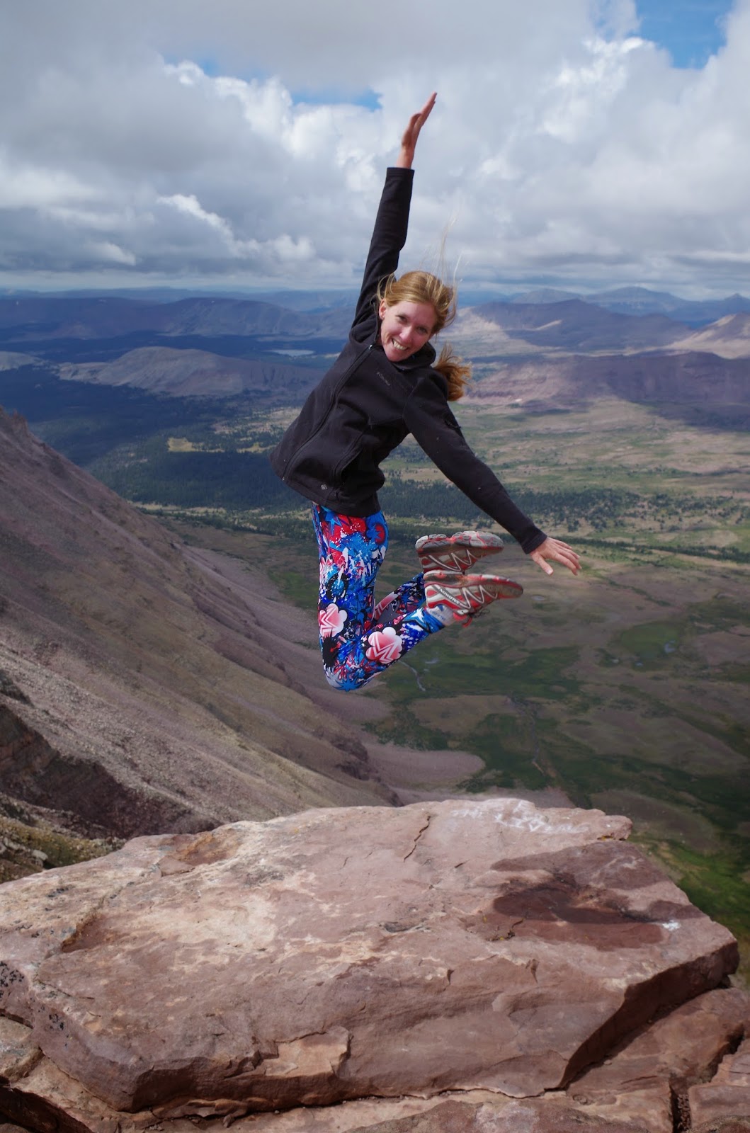
The group from Montana caught up
with me shortly after that and helped me take a great jumping-at-the-summit
picture and just made me feel like a badass.
I felt cool because I’d made the summit in a day, had my kick ass tights
on, was willing to jump near the ‘edge’ of a 2,000 foot cliff (it wasn’t that
close, I was totally safe), and I did it all by myself.
I really enjoyed being able to
chat with the folks from Helena, I think it’s cool how being on the mountain
can make everyone a kindred spirit. But
they also helped pump my ego up until it was almost ready to burst (I don’t
think the low air pressure around helped at all either). I was elated on the way down. The views were so amazing…
 |
| The arêtes and headwalls of this range are still being shaped by ice and frost, which reaches into cracks in the rocks and fractures it (“splits it asunder”), leaving sharp, angular faces that will eventually be buried in their own rubble. |
The signs of life, while short in
stature, were very cool. A few months
ago I learned that lichens can grow in space, so it seemed especially cool so
see them up on the talus slopes I’d seen referred to as a moonscape.


The Uinta Mountains were created by two tectonic
events. The first was a north-south
compression that buckled the crust and exposed the sedimentary rocks that make
up the mountains 60-65 million years ago (they’re actually meta-sedimentary, sedimentary
rocks like sandstone and limestone that have been under compression long enough
to begin changing into metamorphic rocks like quartzite and slate). The Uintas reached their current 13,000 feet
elevations about 15 million years ago as tectonic forces lifted the range along
an anticline.
 |
| Parting shot of the King’s Peak cliff face, ice is still eating away at the rock while gravity is helping build the large talus slopes at the bottom |
 |
| Evidence of glaciers at lower elevations |
 |
| "Felsenmeer" – the ‘block top’ peaks between 10,000 and 12,000 feet that haven’t been touched by glaciers, composed of rubble that has accumulated in place due to “sustained severe climate”, above the U-shaped glacier carved valleys of the Painter and Uinta River Basins. |
All of this pre-historic uplift and erosion made for a long
hike down. I started to think of the
tundra moonscape more like a hell-scape that I wouldn’t ever get out of. The little tundra plants that I’d thought
were so cool before just bothered me now because they didn’t yield to
compaction, making it difficult to find the trail. After chewing over the term ‘hell-scape’ for
a few miles and realizing that I was cold and hungry again, I decided to have
lunch on a big rock over looking Painter Basin.
I reached “Peak Badass” on this rock eating a cheese and humus
burrito. Along came a hiker named Corey
who was doing the really badass High Line Trail (73.4 miles, 9 major peaks, “nonstop
views and rampant wildlife” according to Backpacker) over the course of several
days. Despite his clearly more intense
badass-ery, Corey was nice enough to pump my ego up a little more, as it was
clear I was the only solo female hiker on the mountain that day, and it seemed
the only one doing the peak in a single day.
This was especially nice of him as the effects of HACE may have been
settling in and I was having some trouble following basic conversions (i.e., “My
name is Corey, it was nice to meet you.”
“My name is Becka, what is your name?”).
In the 10 minutes I’d been sitting on the rock the weather had changed
dramatically, as it is known to do in the Uintas, so Corey left noting “The
gnar is coming in.” and I started to pack up my stuff and add a layer of
clothing. I felt very hardcore.
 |
| The gnar coming in |
The snow hit with a vengeance. It was beautiful, but made for slippery
hiking. I passed Corey as he was getting
out rain gear and asked if he was ready for snow while I pulled out my own rain
coat. I’d been pondering whether
lightning can actually accompany a snow storm when something shocked my ear. KERRRACH
BOOOOOOOOOOOOOOOOOOOOOMMMMMMMMMMM!!!!!!!!!!!
Lightning struck close enough to shock me and shake the ground! My ego popped, all signs of badass-ness fell
away. I yelled out something to the
effect of “I’m going to cry” and started running down the trail, single
mindedly focused on getting to tree line or shelter of some sort. I looked like a dumbass. Arms out, feet kicking, slipping and sliding,
literally landing on my ass several times.
I felt ridiculous too. It seems
like a childish strategy to run away from things that are scary as fast as
possible, but that was my strategy in that moment. Tree line was still about 2,000 vertical feet
and 8 miles away. There were some nice
shrubs down in the basin 0.5 miles away, but the storm had cleared by the time
I got there.
 |
| Not just snow - thundersnow! |
Ten minutes later, once the storm and my head had cleared I
stopped to sit and think about what a dumbass I was, and shake my legs out
enough to stop slipping and falling. Of
course lightning can strike during a snow storm, precipitation all comes out of
clouds, which are the source of lightning too.
More research on my part has indicated that there is a thing called “Thundersnow”
and that it is relatively infrequent and localized and terrifying (that same research showed that other
people have pondered the same thing as me, just not during a snow storm, so I
was only half a dumbass). Nothing in my research
indicated being a fast-moving target was an effective strategy for avoiding
lightning strikes (though I did read the opposite advice “Better late in this
world than early to the next”). I waited
for a minute or so, trying to catch of glimpse of my fellow hiker and feeling
like an ass. I'd just been thinking it was so great that everyone on the mountain takes care of one
another and I then literally run past another hiker like a scared little girl. I did eventually see Corey hike on through
the basin after our trails had departed, so I could still feel like a dumbass,
but at least I knew he was safe.
 |
| Crossing Henry's Fork |
The rest of the hike was relatively uneventful, but very
long. I did a bit of wild flower
gathering and noticed the similarities between the few genus’s of plants you
find in wetlands and at high elevations, because there are only a few groups of
plants that seem to be able to deal with such extreme water stresses
(drought/hypersaline water vs. ice). I
ran into my friends from Montana again, somehow already back at camp and
looking very comfortable. I tried to
revisit the bottom half of the trail with new eyes, since I hadn’t really seen
what it looked like when I was hiking it in the dark. Most of my energy went into trying to rid my
head of awfully annoying songs (there’s something popular right now that says “I
don’t care, wo-oo-oo-oh, I really don’t care” over and over again and I hate
it) and working to avoid calculating my hourly pace. There were some dark times.


I wandered back to camp site 15 hours and 20 minutes after I
started, which was 40 minutes earlier than I had originally estimated, so I
patted myself on the back for finally beating my habit of sandbagging time
estimates. I patted myself on the back
again as I cooked up the steak I’d had marinating for the past day, it was a
great reward, even if I had to eat it under the hatch door of my car because of
another rainstorm.
 |
| The peak really cleared up that evening, it's that beautiful peak in the center. |
King’s Peak was probably one of the best solo adventures I’ve
been on, in part because of those large swings in confidence than any long and
tall hike should bring with it. It’s
also just an amazing and beautiful hike.
I’d like to do the High Line Trail now that I’ve learned a lot more
about the geology of the region so I can understand what I’m seeing, plus I’d
have a year to build up my bravery stocks.

No comments:
Post a Comment