The other day one of my friends told me she doesn't know what I do. My sister has told me the same thing before. I even have a wetland manager I interact with who doesn't know what I do. Sometimes I don't know either. It's hard to remember sometimes that everyone I meet doesn't know or care about Great Salt Lake wetland ecology as much as I do. As the conversation with my friend continued, we discussed Radiolab, and how great they are at bringing science to the masses. I'm a big believer in making science relatable and in helping people understand what I do and why they should care, but that's hard work. Everything about graduate school and academia drives you to focus on gaining acceptance from faculty members by catering to their area of expertise and to woo funding agencies by closely following their jargon-laden calls for proposals. All of that aside, I can't think of a way to make my research Radiolab-cool, but I don't have any impending deadlines and thought I'd take a shot at making my research understandable here on the blog.
The official title of my project is "Determining the impact of impoundment and water management on Great Salt Lake wetland condition." Blarg. Long titles can be descriptive, but they're also mind numbing. To show you why you might care about my project I'll deconstruct the title to talk about four things: 1) wetlands are amazing, 2) Great Salt Lake wetlands are extra amazing, 3) impounded wetlands are intriguing, and 4) wetland condition is a way to answer my pressing questions.
1) Wetlands are amazing. Wetlands are soggy places. Some are wet and soggy all year long and some are only muddy for part of the year, but they're all wet long enough to be different from terrestrial environments like forests and deserts, but not flooded deep enough to be considered aquatic environments like a lake, river, or ocean. Wetlands are the swamps, marshes, bogs, and quagmires you've all hopefully wandered into at some point. Wetlands are considered ecotones, they're transitional ecosystems between terrestrial and aquatic environments and share qualities of both. In the larger scheme of things, they look like this:
Upland, wetland, and aquatic ecosystems. The black line represents the soil surface, the blue line represents the water surface.
There are three basic features of wetlands that make them unique and awesome: water, wetland plants, and hydric soils. Water is what makes it all happen; water tends to be shallow in wetlands (less than 30 cm or 1 foot) and slow moving (like in ponds). All plants need water, but having too much water or water that flucutates a lot is stressful to plants because it makes attaining oxygen difficult. Only the toughest, coolest plants grow in wetlands, they're called hydrophytes or water-loving plants and have special adaptations that allow them to survive in wetlands.
Pickleweed (Salicornia rubra) - my favorite - can live in water and very salty places by storing water and salt in its tissues. Its other common name is swampfire because it changes from green to red during the fall. Pickleweed can also be used to salt or preserve foods.
Alkali bulrush (Schoenoplectus maritimus) thrives in wetlands with fluctuating water levels because it can reproduce by seeds on dry ground and through rhizomes that create another stem of bulrush that is still connected to the original plant under flooded conditions. In this way, alkali bulrush can form large, single species stands.
Hardstem bulrush (Schoenoplectus acutus) can grow in deeply flooded wetlands because its stems are full of air pockets call aerenchyma that allow the stem to stay erect until it grows up through the water surface. These aerenchyma can then send oxygen from the parts of the plants above the water to the submerged parts.
Lack of oxygen due to flooding also makes wetland soils different. Without oxygen bacterial decomposers work slower and organic matter tends to accumulate as muck (which is exactly like it sounds) or peat. The bacteria that survive in wetland soils often have to use an element other oxygen to complete cell processes that generate energy. Nitrogen, manganese, iron, and sulfur are converted to different chemical forms by bacteria in flooded soils and that causes changes in color (in the case of manganese and iron) and smell (in the case of sulfur); these are the characteristics of hydric soils.
Wetland soils are the best!
If that isn't enough to convince you wetlands are cool, they're also great places to spot birds! Ducks, wading birds, colonial nesting birds, small birds, big birds, colorful birds, brown birds.... They come from all around (literally, because these birds are migratory) to eat, nest, and rest in the wetlands. This is especially true around the Great Salt Lake.
Birds!
2) Great Salt Lake wetlands are extra amazing. Water is everything in wetlands. Well, water is really everything everywhere, a post for another time. Water is rare in the deserts of the western United States so wetlands are also rare, generally only comprising 1% of the total landscape. But around the Great Salt Lake (GSL) there are more than 400,000 acres of wetlands, primarily at the river deltas. When most people think of the GSL they see barren salt flats and water too salty for anything but brine shrimp, but that's only part of the story.
The saltiest part of the Great Salt Lake
Three major rivers supply GSL: the Bear, Weber and Jordan. The rivers begin high in the Uintah and Wasatch mountains and descend 6,000 feet before reaching the pancake flat expanses of the GSL, where there is less than a foot of elevation fall per mile of distance. In fact, while the GSL covers around 1,700 square miles (more during wet years and much less during droughts) its deepest point is only 30 feet. When rivers meet these flat spaces they spread out into meandering deltas that often support expansive wetlands.
Great Salt Lake wetlands
The wetlands of the GSL have the freshest water closest to the rivers and the wetlands get saltier as they get closer to the main body of the GSL or farther upslope from the rivers. The salinity of the water, as well as how deep and how long the water stays around, determine which plants grow in wetlands. Where water is deepest and most permanent and fresh you get open water wetlands full of submerged aquatic vegetation (or SAV) commonly referred to as pond weeds, which grow completely under the water. Ducks love this stuff because they can eat the seeds and roots, which are full of nutritious stuff.
Sago pondweed above and below
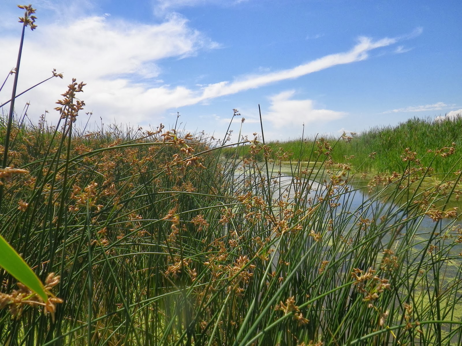
Where water is shallower, usually less than 1 foot, you find emergent marshes; these are the wetlands I study. They're called emergent because the plants here grow up through (or emerge from) the water. Cattails, bulrushes, sedges, and grasses are all types of emergent plants. Water regimes, the patterns of flooding and drying within the wetland, can be very different in emergent wetlands, so emergent plants have the coolest adaptations to life in the water. Birds love to nest in emergent wetlands, where they can find the materials to build and hide their nests.
Duck nests in emergent wetlands
The saltiest wetlands that are flooded least often are called playas. Some playas are so salty the soil surface glitters with a crust of salt. Playa soils might only be muddy during the peak of spring runoff or after a big storm, but when they're wet they're an amazing place to be. Playa wetlands are composed strictly of salt loving plants called halophytes. Shorebirds often nest on playas and larger groups of birds visit after rain storms bring out big blooms of bugs to eat.
That's a wetland full of surprises right there. While it looks solid, you couldn't drive a truck across it without getting stuck
The water in the rivers that supply GSL is primarily from snowpack, every year there is a pulse of high runoff as mountain snow melts, the rest of the year there is much less water available. A series of reservoirs have been built on the rivers to capture all of this snowmelt water during the spring and then release it into canals and pipelines when people need it most (like during the irrigation season for crops). These rivers support the vast majority of Utah's 3 million people who live on the Wasatch Front, and extracting all the water they need from the rivers has caused significant changes to the deltas at the very end of the rivers, generally leaving less water for wetlands when it is needed most during the summer.
Wetland drought is real, my friends.
3) Impounded wetlands are intriguing. GSL wetlands were receiving less water than they needed more than 100 years ago and that started causing trouble for migratory birds, who couldn't find enough food and nesting habitat some years and often died because of diseases in the places they were congregating. One solution to maintaining wet wetlands with little water was to impound wetlands. People who managed wetlands, primarily people who enjoyed hunting, built large dikes around the wetlands that would capture water when it was plentiful during spring runoff and hold the water in as summertime drought came. This turned out to be a pretty good idea and was widely adopted around the GSL, just look
All those ponds with straight boundaries are impounded wetlands, natural wetlands don't have straight borders.
Once you've created an impounded wetland you can manage it like a shallow reservoir to accomplish many habitat goals. If a manager wants lots of open water wetlands full of SAV they might keep the water three feet deep for the whole year. Another manager might want lots of emergent wetlands to support nesting birds so they would keep the water at a shallower level and draw the water level down below the soil surface during the summer. Wetland managers with impounded wetlands can also manipulate the salinity level in their wetlands by bringing in more or less freshwater.
Two large impoundments one mile apart - the left flooded deeply, the right drawn down during late summer
Really, there are many different management possibilities in impounded wetlands. With almost 200,000 acres of impounded wetlands around GSL and a large group of managers who may or may not talk to each other about what they do and the results they see from their management, it's difficult to know exactly what the best strategy for managing water in an impounded wetland is. When I was a research technician at USU (read: helper monkey) I spent a lot of time in these big impoundments wondering if the wetlands outside the dikes were different. I also wondered about the impact of the different management strategies I was seeing, some people chose to keep their wetlands flooded all the time, other people didn't have enough water available to keep their wetlands flooded at all that year. I wondered how managers were making decisions about what to do with their water and how they measured the impact of those decisions.... I had a lot of questions about these impounded wetlands so I decided to do three years of field work in GSL wetlands and then write a four chapter dissertation on the whole thing.
Un-impounded wetlands
4) Wetland condition is a way to answer my pressing questions.
(Yeah, there's a song about condition, but it doesn't sound like they're talking about wetlands.)
Once I committed to a PhD project trying to figure out this whole impounded wetland business I had to figure out a way to measure the impact of impoundment and condition assessments seemed to be the way to go. My condition assessment is based on the vegetation within each wetland, which I will survey for at least three years. Based on a survey of the plant community, I hope to be able to say how much a site deviates from a natural state and how stressed a wetland is based on the plant traits mentioned in section 1. In this way, I can judge each wetland (and I'm surveying 50 of them) as excellent, good, eh, and poor. For example, a wetland in excellent condition would be composed only of awesome, native species (no weeds here) and have a water regime that looks normal (not too deep, not too dry). A poor condition wetland might have lots of weeds and spend too much of the year too dry to support cooler wetland plants.
From left to right: Excellent, Good, Eh, Poor
I have to do this for at least three years because I don't know what the most natural state is, or whether it changes during a flood year or drought year. I also didn't start with a good idea of what the water regime looked like and would like to track that for a few years to make sure I get it right. Every summer I go out to 50 sites scattered from Corinne to Saltair and look at what plant species are there and how much of the wetland they cover. I also dug soil pits to see how the soil might be different and I've installed piezometers to measure water level. Piezometers are wells I made that are stuck in each wetland as deep as three feet. In each piezometer I put a pressure transducer that measures the weight of the water in the well every hour, it then calculates that weight as a water depth. They're dang snazzy and show exactly how water levels change according to seasonal changes or management actions. Just look at the graphs I can put together with them.
Examples of wetland water regimes put together based on my piezometer data.
With all of this plant, soil, and hydrology data I hope to not only say what condition GSL wetlands are in, but also what the impact of impounding and managing water is on wetland condition. And to get at all those questions about what managers are doing with their water I'm going to conduct interviews with them. I'm pretty sure that these wetland manager's heads are full of all sorts of interesting and important observations about the wetlands they manage and I want to hear it all.
I've only got preliminary results so far, but I can see that impounded wetlands are different from un-impounded wetlands because they are usually flooded for a longer part of the year. Because the water level is higher in the impoundments there are more wetland plants. In wetlands where the water level gets really low (more than 2 feet below the soil surface) I've found more species of plants you would usually find in drier places (I call them weeds, because I don't think they belong in my wetlands).
Nodding beggarstick, a plant not often found in impounded wetlands.
Now that you've read through all of this, I need a favor from you. Will you please do your snow dances or say your prayers about snow or send out your good snow ju-ju into the universe to help us toward a good water year in Utah? Please? Without a good winter this year I will have to do four years of field research, rather than three, because I need to see what GSL wetlands look like in a flood year, or at least a normal year. Since I started my project we've had two pretty severe drought years. I NEED MORE SNOW! Another year of field work wouldn't be the end of the world, but it would definitely delay attainment of my doctorate, and I want it ASAP.
So there you have it, why I would study GSL wetlands and how I intend to determine the impact of impoundment. And my desperate plea for snow.
Sorry for the blogging hiatus. I've been "in the field." This means that I spend 12-15 hours a day travelling, working, and cleaning up after work. The rest of my day is usually spent in search of food and trying to relax so I don't have dreams about being the field. I'm three weeks into my field season, with one to go, and up until last night I hadn't had any field dreams. I was pretty sad when I woke up this morning and remembered two points during the night where I had to sit up and remind myself that I was not out in the field, there was so no work that needed to be done, and that I needed to go back to sleep. If it seems like I pack a whole lot of work into just a few weeks of the summer, it's true, but that's the way plant-based field work goes. I need to survey the vegetation of my 50 sites within as short a period of time as possible, so that I'm surveying each site at a point where they are all comparable. It's tough work, but not as hard as the work my technicians are doing. That's right, technicians in the plural. I thought this was going to be a wicked easy year, but because there's a critical mapping component that needed to happen, I've got a crew of 3-4 (and sometime 6) that I take out four days a week. And they've been awesome.
Really, this season has gone far more smoothly than last year, but I still have a few complaints -
1. I hate wading through cow poop. There's too much cow poop in my wetlands! There are too many cows in my way. They're inconvenient and I hate them.
2. It's hot. Too hot. It's drying up all my wetlands.
3. I'm taking too much expensive equipment out into the wetlands, between the tablet, 2 lab gps units, an Archer gps unit, and the rtk GPS, there's a lot of stuff I could break/drown.
But all of these complaints have a bit of an upside
1. Only one of my piezometers has been disrupted by a cow. And by eating all day long, the cows might be opening up the canopy of some of the more invaded wetlands to allow shorter native species to come in (the juries still out on that one though).
2. When wetlands are dry the cow poop dries and I don't have to wade through it. And drought is a natural part of wetland hydroperiods (unfortunately, this might be too much drought).
3. That expensive stuff is providing some really cool data. And using my tablet makes it so I don't have to spend weeks entering all of this data (but I did really enjoy the 3 seasons of Buffy the Vampire Slayer I watched while entering my data last year).
I know it's a little early to pack it in and say Mission Accomplished, but I'm ready to post some of my favorite field work images, so here goes.
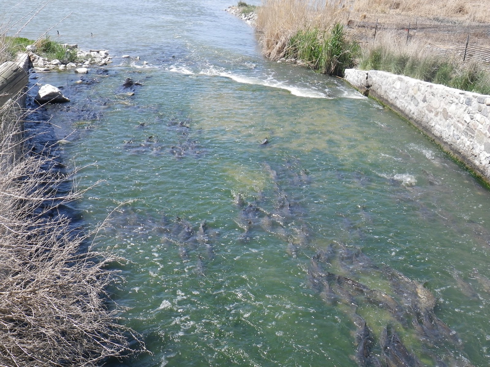
Those grey things in the water there are carp, they're a pretty big problem. They grow huge and spend their days uprooting aquatic vegetation and terrorizing me (no joke, I kicked one on Friday and screamed like a little girl).
I hope Chaco appreciates all the foot prints I've left in the mud. I sure enjoy them.
This is Bull thistle, but growing up we called it a Man Eating Plant, and that's what it's doing there, eating my arm, obviously.
Here you can see a lady bug, old Phragmites that has been sprayed with herbicide, and smoke from Phragmites fires in the back ground.
One of my favorite grasses: Hordeum jubatum or foxtail barely. I think it's pretty.
Storms over the Promontory Mountains. I've become a little obsessed with these mountains in the past few years. Tragically, they're mostly privately owned, so you have to obtain special permission to hike to those peaks.
Super awesome field technician, David, and his spirit animal - The Praying Mantis.
Look closely, there's lots of damselflies hanging off the Kochia. It's the only thing Kochia is good for.
We were out in the field during that period of the summer they were measuring precipitable water - the amount of water that could be evaporated and come down in thunderstorms. There were a lot of thunder clouds that missed us, but these one at least shaded us for some of the day.
My cattail spear. And Frog Togg.
Wet lands?
I really can't complain about days like this, we got a boat ride out to our awesome sites, and there were clouds. And we never once had to push the boat out of the mud. Luck was on our side that day.
Double crested cormorants like to hang out of rocks and trees. It's kind of an odd site, but also awesome.
The most common marsh mammal around the Great Salt Lake. This one completely justified my fear of cows, as it still has horns and was pawing at the dirt and snorting just like aggressive cows do in the movies.
The field vehicle was having some problems, perhaps in part due to the air filter full of grass, seeds, and entire bugs.
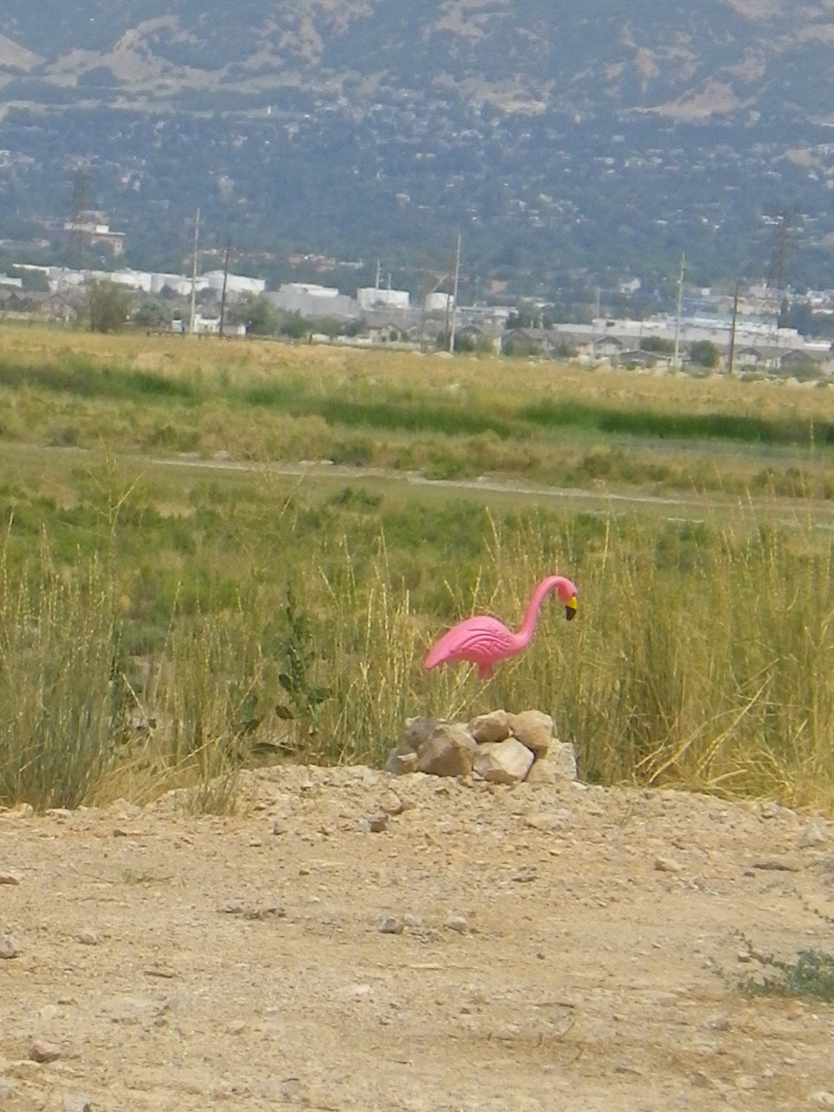
The rare Great Salt Lake Flamingo. A mighty fine site for sore eyes.
Evidence to suggest that this was once a wet wetland.
Pelicans are pretty great, and in the mornings we get to see whole flocks of them flying overhead.
I am very fond of mud, pickleweed, and adventures.
Our very first rain and thunder storm! Only downside was that we were in the middle of a pond with a 5 foot long steel auger and an rtk GPS on a 6 foot pole. Don't worry, no one was hurt.
My Wetland Warriors. And the rtk.
Marsh Mammal #2, the noble Phragmites deer, prancing gallantly through the marsh.
Long billed curlew, one of my favorites. They nest later in the season (around June) out of the playas, so they spent a lot of time harassing us while we installed piezometers.
All of my thinking about successfully winging it has gotten me thinking about a less successful time I went forth without a plan. I call it "The Time I Got Lost in Phragmites." Phragmites australis, or the Common reed, or Phrag, or That Awful Tall Stuff is an invasive, perennial grass. Around the Great Salt Lake if forms dense stands that are literally swallowing the lake. It's horrible. I'm currently the only student in my lab not studying Phrag, but I still find it nearly everywhere because it has been so successful around the lake. Here are some of the reasons it's so successful:
Prolific seed production, in addition to the ability to expand via rhizomes.
It grows 10-15 feet tall.
It expands rapidly, quickly out-competing the native species you see growing in the foreground.
Through rapid growth and growing so tall, it effectively excludes all other species, form monotypic stands.
It also grows very dense, making travel through it exceedingly difficult.
One day, last year, I had a really traumatic field experience in the Phrag. If you haven't been able to tell, I'm generally a woman without a plan. This has made an entire summer of field work kind of difficult, because I have 50 sites and last year I needed to visit each site twice. I really winged it the entire summer. While I had a well thought out protocol for gathering data once I got there, I was figuring out which site to go to on a daily basis. This not only made it so I didn't sleep well, as my dreams were haunted by semi-conscious field day planning, and I used more gas than perhaps I needed to. One day I had a plan to work more efficeintly by visiting a field site along with another errands I had to run. This story proceeds as a series of bad decisions I made on the fly.
Bad decisions #1: making field work part of a day I wanted to get anything else done in. Field work needs to be an all-day thing, you start in the morning and end before the hottest part of the afternoon. One day toward the end of the field season, I was having a really traumatic day and I think that set the stage for all the poor decisions that followed. It was a Sunday evening early in September and I was taking Brent to the airport, where he would be catching a flight to Houston, Texas for three weeks, or three months. I was unhappy about that uncertainty and already missing him. Since I was already going to be at the airport, I thought it would be an effective use of time and gas to jump on over to one of my nearby field sites. This was not a good time to "just" make a field visit.
The field site I intended to visit is located on the beach near Saltaire, and it's a really cool site where all the saltiness and weird water patterns have lead to some really cool plant communities and soil properties.
Parts of the site are dominated by salt grass, pickleweed and alkali bulrush; three of my favorite species.
Proximity to the Great Salt Lake itself makes it a super salty site.
Bad decision #2: Accessing field site from the wrong side of the Phrag. Unfortunately this area has some really large, vigorous stands of Phrag. The easiest way to access this site is from the marina, but the gate to the road out there was going to close at sunset and I didn't want to get locked in. So I parked at the nearby concert venue, on the other side of the beach (read: the other side of the large Phragmites patch). In the beginning, my walk across the beach was awesome, it was a stroll across sand and short plants, temps were starting to cool and I was feeling productive.
I've heard this smoke stack is taller than the Empire State building. When visible, it provides a good bearing toward my site.
I said it before, the sunsets on the GSL are the best ever, and they tend to make the western mountains look a bit like Mordor.
As I neared a large stand of Phrag, my GPS told me the site I was aiming for was about 550 meters away due southwest; basically I was almost there. I made sure all my pockets were zipped and my stuff all safely stowed away from the Phrag's prying grasp, and began to push my way through. As I mentioned early, Phrag is difficult to walk through because it is very dense. Its nearly impossible to walk a straight line through, this patch was even more difficult because there was knee deep water and seeds were being released.
The point of no return. Or the point at which I should have returned.
After a minute of pushing through I realized that it would be impossible to push my way through while holding onto my GPS/compass, so I took note of the orientation of wind blown stems as a way to orient myself and pushed on with both hands. This strategy quickly went bad, as the stems weren't all blown in the same direction and I was being pitched back and forth a lot. Further complicating matters, I am pretty severely allergic to Phrag and could not breath well through all the mucus my body was producing. Here is what my journey looked like:
Journey overview. All together I had a 2 mile round-trip walk. I completed 1.85 miles of it. That bright green area between the beginning and destination is all Phragmites australis.
My path through the Phrag. I began in the south and moved clockwise.
Bad decision #3: Not checking in with anyone. After 15 minutes of pushing through the Phrag, pulling the GPS out to check my progress, and continuing to push through I came to the following conclusions:
I could not maintain my bearings anymore, I was just walking in a circle (literally). After 15 minutes of dedicated work, I was only 17 meters closer to my site, but still more than 500 meters away.
The sun was setting and I was standing in water that had been shaded all year, it was cold.
No one knew where I was.
This last one really distressed me. When going into the field by myself I usually check in with Brent, but he was on a plane. I could have checked in with my field technician, which I have also done, but I didn't want to bother him on the weekend. And now I was too scared to pull my phone out of the ziplock bag I stored it in because I would inevitably drop it. Plus, who was I going to call? I knew my position on the globe because of my GPS unit, but I didn't know how anyone would get there.
View to the north
View to the east.
The south.
The west.
Phrag face.
These are silly excuses for putting myself out in the field without anyone knowing, but that's a result of hindsight. At that moment, I almost started to hyperventilate, but I was too full of snot and Phrag seeds to breathe regularly. Because I couldn't totally freak out, I calmly decided to bail. The point I bailed was really, stupidly close to the point I started in, so I could find my way back to the channel, back across the beach, and to my car.
The lost in the Phrag experience was very humbling to me. I had already known I have a poor sense of direction, but I've felt confidence in my field sites because they're flat and I can see the Wasatch Front to get my bearings. None of this matters in the Phrag. I knew I was a crier, prone to tears at a change of the wind, but it seems I also make even poorer decisions when upset. Finally, it seems I had to learn the always-leave-a-note lesson for myself, despite having read Aron Ralston's book about not leaving a note.
While I will spend the rest of my life generally without a plan, I will not ever go into the Phrag by myself, and I will never start a field excursion after 1:00 pm. And if you're a field monkey, you too should learn from my lessons and don't put yourself in the Phrag alone.